

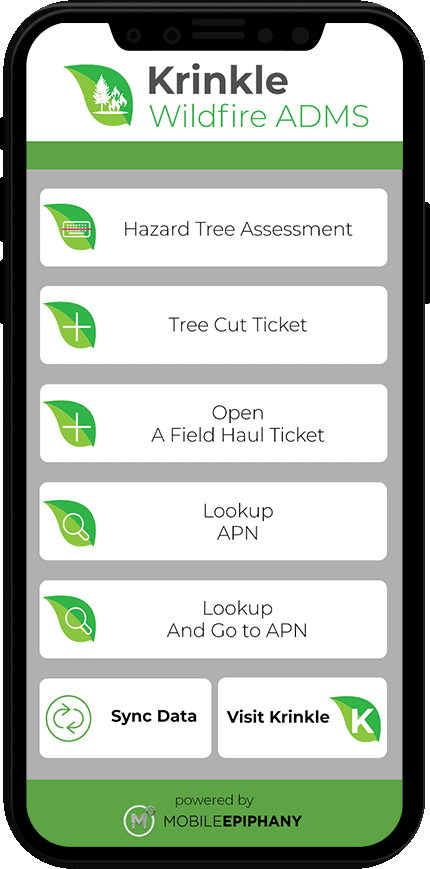
For those organizations that need to manage a post-wildfire debris removal and hazardous tree removal mission, Krinkle Wildfire ADMS® is the nation’s only field-proven software solution. The software has completed multiple wildfire operations across California since 2017. Wildfire operations served by Krinkle Wildfire ADMS® include Paradise, Butte, Klamathon, Woolsey, Loma Rica, Marysville, Bangor, and more. Krinkle Wildfire ADMS® consists of a mobile application for every role in a wildfire mission, is fully Google Earth and ESRI compatible, and includes a complete suite of thorough reports. Mobile application users are guided through the unique processes of their role for every task required in the mission.


SPECIFIC USER TYPES & THEIR ROLE-SPECIFIC GUIDED PROCESSES IN THE MOBILE APP INCLUDE:
• Arborists (working with monitors) can mark and barcode fire-damaged hazardous trees
• Foresters can override an arborist’s decision to cut or preserve a tree or assist when uncertain
• Foresters can request land survey details to ensure proper PPDR attribution
• Recycling/soil sampling monitors can guide and document environmental and recycle debris separation crews
• Monitoring company data admins can manage automated reconciliation and reporting
• Debris haul monitors can record all debris types and manage Debris Hauling Trucks
• Tower monitors can evaluate debris by cubic yardage or weight upon arrival to a DMS, recycling facility, or final drop off
• LH (leaner, hanger) cut-down monitors can evaluate eligibility and issue LH cut tickets to crews
• Stump extraction monitors can evaluate eligibility and issue stump extract tickets to crews
These are only a few of the roles and capabilities tracked in the system. Debris monitoring companies, hauling companies, Emergency Operations Centers (EOCs), and jurisdictions will be able to manage their entire mission within the system, from start to finish.
THE PPDR MISSION STARTS WITH RIGHT OF ENTRY, INSURANCE, AND OTHER ACCUMULATED DOCUMENTATION
PPDR missions, which are very common in wildfires, create unique challenges that are not part of Right of Way (ROW) missions. They need specialty tools to manage them. Krinkle Wildfire ADMS® understands this and delivers.
Scroll down and select “Read More About PPDR Missions” for more expert details.

Click Image to Enlarge
Krinkle Wildfire ADMS® simplifies one of the labor-intensive aspects that must be completed to initiate the PPDR mission: importation of jurisdictional APN (privately owned land parcel) data. Sometimes tens of thousands of APNs must be uploaded into a mobile system to be referenced in the field on many mobile devices. Even more labor-intensive is acquiring, storing, and associating the private land parcel data with a slew of critical documents. Those documents include the Right of Entry (ROE) forms, owner insurance policies, overhead survey images, etc. Finally, all this data must be encrypted on a user’s mobile device for complete security and always be ready and easy to look up. It has to work even when the internet is not available, and Krinkle Wildfire ADMS® has this under control.

Click Image to Enlarge
The initial acquisition of these critical APN documents is a struggle of its own. Often, acquiring these documents is an assortment of processes ranging from in-person meetings with homeowners, to email and phone call campaigns imploring homeowners to submit their documentation via mail or email—finally, extraction of the APN/address parcel data from existing government systems. Krinkle Wildfire ADMS® has solutions and processes to manage all these typical methods, even if a few strategies must be deployed simultaneously to build a complete APN/parcel database.


Click Images to Enlarge
Once these documents are acquired and integrated into the Krinkle Database through these methods, Krinkle Wildfire ADMS® allows secured access via a fully encrypted mobile app (iOS or Android, Phone or Tablet). In addition to allowing field users to look up their land parcel data and document images when not connected, the system also provides a comprehensive set of lookup methods. Users can do lookups by entering partial addresses, partial APN numbers, or geospatial proximity to the parcel using Krinkle’s online and offline mapping capabilities.


Click Images to Enlarge
LOGIC FOR DETERMINING A TREE'S SPECIES-SPECIFICPROBABILITY OF MORTALITY (Pm)
One of the most unique and sophisticated aspects of Krinkle Wildfire ADMS® is its ability to assist Arborists and Registered Professional Foresters (RPFs) in their unique science-based mission. Nothing about a hurricane-specific ADMS (i.e., Krinkle’s Debris Tracker®) can prepare a Wildfire ADMS to effectively guide Arborists in determining which trees are fire-damaged hazardous trees. The science of a wildfire’s effect on a tree is far too unique and complex for other ADMSs to be of use.
Scroll down and select “Read More About How We Help Arborists and Foresters” for more expert details.

Click Image to Enlarge
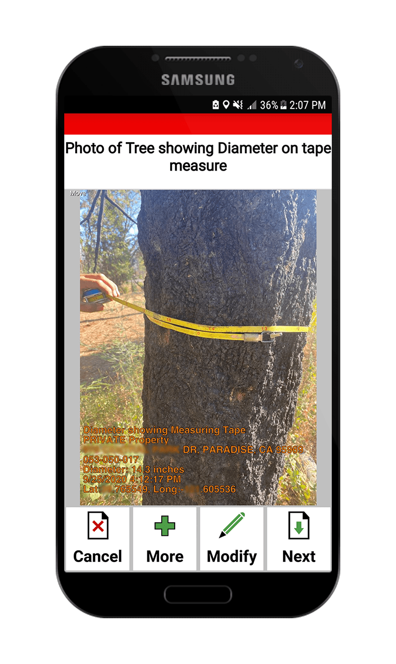
Not only does Krinkle Wildfire ADMS® guide arborists throughout determining which trees should be cut vs. preserved, but it also guides them on how to properly barcode each tree uniquely (if the mission requires barcoding), how to mark the tree correctly (usually with spray paint) for future felling (or preservation) and it ensures that their device captures the best possible GPS position data. For years, the system has been refined in multiple live wildfire operations to its specific purpose.


Click Images to Enlarge
Krinkle Wildfire ADMS® not only guides its processes based on the many different species of trees that foresters and arborists will encounter in the mission. It also directs arborists to enter the appropriate data they use in their modern science to determine a tree’s Probability of Mortality (Pm). The analysis of the data collected is built into Krinkle Wildfire ADMS®. Data collected and analyzed by the system includes the quantity of frass, the presence of beetle tubes, the percent of the tree’s crown killed or scorched (PCK or PCS), and the condition of the cambium and all the other variables used in modern forestry science to determine Pm.

Click Image to Enlarge
The unique science of determining which fire-damaged trees are a hazard to the public is built right into the mobile app used in the field. Krinkle’s software engineers have worked with multiple Arborists and Foresters over the years to fine-tune this process. They have also incorporated the scientific equations and rules-based lookup tables developed by the USDA Department of Forestry and other academic sources to ensure a solid analysis tied tightly to today’s most current and accepted forestry science.
The system guides (but NEVER overrules) the Arborists. When an arborist is uncertain or requests assistance in determining if a tree should be cut or not, the system automatically passes a request, complete with the images and tree data, to the Lead Forester’s mobile app for their input. The Lead Foresters in the mission ALWAYS have the final call on any tree the arborist is uncertain about. After all, the Registered Professional Foresters have years of education, training, and experience to make a final call. In fact, the RPFs decide the threshold for probability of mortality (Pm) must be exceeded (by individual species) before the system suggests cutting it down. This maximizes the appropriate preservation of trees while optimizing the speed and accuracy of the mission.


Click Images to Enlarge
Foresters can review data collected at the tree, analyze it and run reports from Krinkle’s PC-based back-office tools. Still, they can also perform their field tasks, including looking up data, reviewing trees, and making the final call on a tree directly from any mobile device (phone or tablet). They can even run reports from their mobile devices. The system is incredibly powerful and versatile.

Click Images to Enlarge
Everything from high-resolution images stamped with the unique barcode ID placed on trees, its GPS data, and the address (APN) in question are placed at the Foresters’ fingertips. The mobile app makes it easy for them to view trees needing their input from anywhere they are. Even turn-by-turn directions are built into the system, making it easy for them to visit the tree, as is often required.
Click Image to Enlarge
THE DEBRIS HAULING MISSION IN WILDFIRES IS WILDLY DIFFERENT THAN THOSE FROM HURRICANES
Many aspects of the debris hauling mission make a Wildfire ADMS very different from an ADMS used after a hurricane. These unique requirements for a Wildfire ADMS are amplified even more in Private Property Debris Removal (PPDR) missions, which are common following wildfires. It will likely fail without specialty PPDR subject matter expertise and experience built into a Wildfire ADMS. Krinkle Wildfire ADMS® was created to ensure the right subject matter experts were consulted across the industry, and the proper experience-based knowledge was built into the comprehensive system.
Scroll down and select “Read More About Why Krinkle Wildfire ADMS is Different from Hurricane ADMS Systems” for more expert details.

Unlike hurricanes, and especially in the PPDR mission of wildfires, the property parcel in question contains far more complex debris streams, different processes, and ecological issues than are manageable by a hurricane ADMS. Fires require attention to the ground and air toxicity issues, debris management processes, and debris types that hurricanes do not. Whether Krinkle Wildfire ADMS® is field-proven in understanding how to uniquely deal with ash and burnt debris, the multitude of unique recyclable materials, or the environmental requirements of toxic soil sampling, Krinkle Wildfire ADMS® is field-proven. Even when some debris streams are tracked by weight while others are tracked by cubic yards or piece counts simultaneously, Krinkle Wildfire ADMS® is ready. These unique aspects of wildfire tracking and more are managed within the system.


Click Images to Enlarge
A FLEXIBLE SYSTEM WITH GUIDED PROCESSES
While Krinkle Wildfire AMDS® guides its users through marking trees for cut and automatically calculates math like Probability of Mortality (Pm), arborists retain the ability to override the system and request a forester’s opinion. Foresters have their own module within the mobile app where they can easily filter through hazardous tree assessments and quickly find which trees require their review. Additionally, foresters can further escalate the issue by consulting with land surveyors on which piece of property a given tree resides. A module even exists for the affected jurisdictions to monitor the ongoing Work-in-Progress (WIP) and run reports.


Click Images to Enlarge
It’s critical to understand how flexible and quick to adapt a Wildfire ADMS must be to succeed. Hardcoded systems would be essentially useless in this ever-changing environment. The rules set forth (and often changed mid-project) by the jurisdiction and the unique approvals from FEMA in each fire must be accommodated by a quick configuration of the system. New species of trees may need to be added. New rules on when to cut certain species may be required by the forestry team. The possibility of changes in the 11th hour of any project (or after it has started!) is not only likely; they are common. Rigid systems cannot adapt. Krinkle Wildfire ADMS® can. It is built on top of Mobile Epiphany’s patented and award-winning Mobility Platform. Its “Rapid Application Configuration” capability (RAC) is one of a kind in rapidly-deployable enterprise-class mobile systems. You can read more about Mobile Epiphany’s decade of experience and the underlying technology driving Krinkle Wildfire ADMS® at Mobile Epiphany.
Click Image to Enlarge
EASILY MEET & EXCEED FEMA STANDARDSSUPPORT POST-MISSION AUDITS
Krinkle Wildfire ADMS® meets and exceeds all the FEMA data tracking requirements during the debris removal mission. Our application is a step-by-step guide for every monitor, arborist, forester, recon team leader, truck certifier, etc. Our advanced system incorporates all of FEMA’s documented best practices, processes, and forms from their official documents, including the PAPPG and beyond. Simplify and speed up the FEMA reimbursement process, support future audits by the federal government and keep your data organized, accurate, and up-to-date with Krinkle Wildfire ADMS.
ADVANCED REPORTING CAPABILITIES
Whether you’re a monitoring company, hauling company, emergency operations center, or a self-monitoring jurisdiction, Krinkle Wildfire ADMS® instantly provides all the relevant and necessary geospatial and summary reports you will need. Our variety of valuable reports tracks the ongoing progress of every aspect of the project and auto-reconcile all payments associated with the debris removal effort. The auto-reconciliation process also has a robust, built-in set of methods to detect tickets that have anomalies and require investigation before authorizing payment. Krinkle calls this its “management by exception” capability, which is highly efficient in the reconciliation process. The system gives you the ability to run progress reports by date range (for cubic yardage or weight operations), a variety of reimbursement and anomaly detection reports, hazardous tree recon and post-cut reports, geospatial reports compatible with Google Earth, ESRI, and many more. Krinkle Apps can build custom reports quickly to meet those last-minute requests by the client. Reports are generated at the touch of a button and can be filtered by barcode, date range, APN number, and any relevant attribute for quick data visibility.
To review our entire suite of reports, schedule a demo now.


Click Images to Enlarge
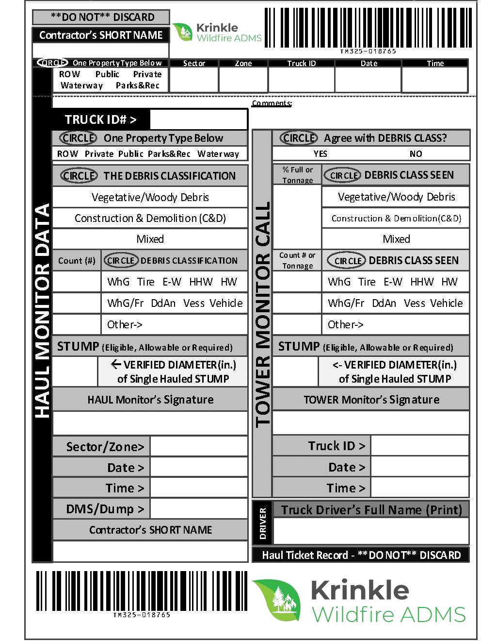
WIRELESS PRINTING OR PRE-PRINTED TICKETS. IT'S YOUR CHOICE!
Krinkle Wildfire ADMS® supports wireless printing and pre-printed tickets for the debris hauling, fire-damaged hazardous tree cutting, and stump extraction portion of the mission. For those missions that prefer battery-powered field printers, both Apple Print® and Android Print® are fully supported. These printers connect directly to Krinkle’s apps on your mobile devices, and no live internet connection is required. You can also purchase pre-printed tickets directly from Krinkle.


Click Images to Enlarge
GOOGLE EARTH & ESRI COMPATIBILITY
Krinkle Wildfire ADMS® is fully integrated with Google Earth which allows users to easily and quickly create a geospatial view of all concerns identified as well as user work (such as “Work Crumbing “and “Bread Crumbing”). The data can be saved as a file (.KMZ and .KML file formats) from our secure reporting portal and viewed on Google Earth. Krinkle Wildfire ADMS® can also convert them to ESRI Shape Files.


Click Images to Enlarge
A COMPETITIVE ADVANTAGE FOR YOUR RFPS
An ADMS is essential in winning jurisdictional contracts and debris monitoring RFPs (Requests for Proposal). Krinkle Wildfire ADMS® will give your company the competitive advantage needed to win RFPs as the prime contractor. In addition, we offer complete support documentation, which you can use to enhance your RFP with answers to common and not-so-common questions and screenshots, example reports, and more. Completing the ADMS section of your RFP will have never been more straightforward and comprehensive.
CAPTURE CONTRACT TERMS AND AUTO-CALCULATE PAYMENTS
Krinkle Wildfire ADMS® doesn’t just track debris; it also allows monitoring companies or jurisdictions to enter all the specific payment terms associated with the hauling and cutting contract. This allows you to easily see what is owed and who it is owed to at any point in the mission. Payment terms between debris removal companies and their clients can be highly variable and incredibly complicated, but our software keeps track of them and automates the calculations. Everything from weight-based operations, tare weight-based operations, and cubic yardage operations are covered. Even when mileage driven by the hauler affects payment, Krinkle Wildfire ADMS®’s payment reconciliation system is fully integrated to google maps, automatically calculating the driving distance (NOT the distance as the crow flies) and associating the proper drive distance to the right “miles driven category” fee.
Krinkle Wildfire ADMS® can enter nearly every combination of payment possibilities into the system, and amounts owed will be automatically calculated and reported on instantly. The time saved by instant “payment due reconciliation” cannot be overstated.


Click Images to Enlarge
ELIMINATE REDUNDANT DATA ENTRY
After a wildfire, hazard tree marking, feeling, and debris removal can take months. All of this recorded activity by the monitors can produce countless data records that used to require input into spreadsheets. This task is time-consuming, costly, mind-numbing, and prone to human error. Wrong or missing data is often the result. Krinkle Wildfire ADMS® eliminates hours of redundant and erroneous data entry. All the data from the field will be captured electronically, even when no internet connection is available. The user’s mobile device or tablet will automatically transfer all the data, images, GPS positions, signatures, and more back to the reporting system when a network connection is reestablished. Nothing prevents work from moving ahead. Keeping track of critical data on paper will not be an issue, and reports will be instantly available.
WORKS OFFLINE FOR HOURS ON END
Wildfire zones and other disaster areas are not known for their available cellular networks. Destroyed cell towers can be down for months, and connectivity is often unavailable in the field. The Krinkle Wildfire ADMS® mobile app can work for hours without a network connection, and a connection to a network is only needed once or twice each day.
PRICING
The Krinkle Wildfire ADMS® software suite includes everything your company needs to monitor, track, and report on the debris removal processes throughout a mission. You will only be charged when monitors actively use it during live projects. Training on the system is included in the initial setup fee.
Prime Monitoring Companies
Setup Fee |
|---|
$2,500 |
One Time Setup |
*Includes 8 Hours of Training |
Full Document Support for RFP |
License Fee |
|---|
$3.25 |
per project hour |
Prime Hauling Companies
Setup Fee |
|---|
$2,500 |
One Time Setup |
*Includes 8 Hours of Training |
Full Document Support for RFP |
License Fee |
|---|
A small percentage of the contracted rate between Hauler and Jurisdiction, applied to all debris types (CYs, Tonnage & Per Piece Hauling), |
Self-Monitoring Jurisdiction
Setup Fee |
|---|
$2,500 |
One Time Setup |
*Includes 8 Hours of Training |
Full Document Support for RFP |
License Fee |
|---|
$1.50 Per Cubic Yard for Non-Reduced (ROW, PPDR, etc.) |
Unlimited Users, Unlimited Reports, and Unlimited Support
*Speak with a Krinkle Wildfire ADMS® representative for annual contract details and terms
MUST BE PRE-ORDERED 3 WEEKS IN ADVANCE
*prices do not include shipping and are subject to change.
Quantity | 5-Part Carbonless | 4-part Carbonless |
|---|---|---|
1,000 | $337.50 per thousand | $305.20 per thousand |
2,500 | $306.45 per thousand | $265.65 per thousand |
5,000 | $289.90 per thousand | $244.90 per thousand |
7,500 | $270.25 per thousand | $228.55 per thousand |
10,000 | $256.00 per thousand | $216.15 per thousand |
*Overnight shipping available when Emergency Tickets are in stock
*prices do not include shipping and are subject to change
Quantity | 3-Part Carbonless | 3-part Carbonless |
|---|---|---|
1,000 | $350.00 per thousand | $350.00 per thousand |
The pricing philosophy of Krinkle Wildfire ADMS® is based on simple, hourly-based billing and a one-time account setup fee. Only pay for the users that are using the app, with no monthly subscriptions or additional licensing fees. Software-as-a-Service always includes all end-user support and all software updates are included. Our sophisticated smart forms, in coordination with our workflow capabilities, keep your projects organized and moving forward. Any additional customization requests are also readily and inexpensively available but are rarely needed. The system is already comprehensive. Finally, our application can be used from the device you already own or we can offer you hardware options for purchase or lease.
KRINKLE WILDFIRE ADMS® –
(THE IOS & ANDROID MOBILE APPLICATION)
Contains all the required smart forms, guided process flows and unique user role applications needed for managing debris removal tasks requiring data collection and data reporting. Our smart forms were developed in cooperation with debris removal and monitoring company subject matter experts (SMEs). No limit is placed on the number of devices running the mobile app. Download the application on as many devices as needed.
KRINKLE REPORTING MANAGER® –
(RUNS ON A PC & MOBILE APPLICATION)
Generate reports from any PC or mobile device. Provide jurisdictions with the required debris monitoring reports. You can even give them the reporting tools to run on their own. These reports can be generated instantly and can be formatted how you would like (MS Word, MS Excel, PDF). Run as many reports as you need, and do so from as many PCs or mobile devices as you would like, at no extra charge.
KRINKLE DATA EXPLORER®-
(RUNS ON A PC)
Sometimes formal reporting output is not what users are looking for. Data Explorer is a quick way to view, sort, and filter the data as soon as it comes in. This allows users to view data and get answers to questions they may have in ways that pre-existing reports may not. Data Explorer is a simple-to-use, valuable PC tool that allows managers and administrators to easily review and organize all the data coming in from the field. Build and run custom searches with minimal training. Sorting, filtering, and exporting data to excel for any purpose is easily achieved by all administrators of the data.
DOES YOUR COMPANY NEED OTHER CUSTOM FORMS OR GUIDED PROCESSES IN ADDITION TO WHAT'S INCLUDED?
Mobile Epiphany’s team can build any number of custom forms faster & more cost-effective than any other solution. Learn more about our platform technologies by clicking the link below.